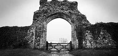
New research has shown that the tiny hamlet of Dunwich on the east Anglian coast is the last fragmanet of an important trading city that existed in the east of England and would surely have been the port of interface between England and Holland.
Dunwich was a medieval metropolis. Eight churches, 80 ships, five religious orders - including the Benedictines, Dominicans and Franciscans. It was as rich as London from its trade in wool, grain, fish and furs. Such was the city’s prestige that, under Edward I, it was granted two seats in Parliament. There is still a map of of it under the sea dating from 1597 and it appears in the domesday Book.
By 1173 Robert, Earl of Leicester, tried to land 3,000 Flemish troops on its beaches in an attempt to depose Henry II and replace him with his son.
In 1205 there were five royal galleons in the city – a similar number to those in the Port of London – while in 1242, when the truce between King John and the French monarch broke down, Dunwich was able to muster 80 ships to go to the King’s aid.
The demise of Dunwich, perched 14 miles south of Lowestoft, gathered pace in 1286 when a huge surge hit the East Anglian coast. Within 50 years hundreds of houses and other larger buildings had been consigned to the shallow reaches of the North Sea.
Another fierce storm in 1328 destroyed the Benedictine cell, an offshoot of Ely Cathedral, and swept away the Franciscans’ Greyfriars priory and the Dominicans’ Black-friars priory. Two decades later a tempest swept 400 houses, two churches and various shops and windmills into the sea.
In 1510 a pier was erected as a breakwater when the sea approached the market place. The churchwardens at the cruciform church of St John the Baptist sold off all the plate to raise money to build another pier to deflect the waves from their church, but it, too, went over the cliffs in 1542.
